“Another major experiment which affected Glacier was also to affect many other national parks. The program was part of President Franklin D. Roosevelt’s New Deal and was called the Civilian Conservation Corps. In 1933, almost immediately after this program’s enactment, young men from all over the United States were organized into work crews in camps in national parks and forests. Responding to the Depression economy and vast unemployment, Roosevelt intended this labor to enhance the conservation of natural resources while providing a livelihood for indigent young men. Nationwide, over a thousand camps organized by the Army employed some three hundred thousand young men, and in Glacier, some sixteen hundred enrollees arrived and eight camps were established in 1933.” – C. W. Buchholtz in Man in Glacier, 1976, Glacier Natural History Association
Those of us who became addicted to Glacier National Park over half a century ago, learned more about the park by reading books and monographs published by the former Glacier Natural History Association, for which I was a volunteer, that drew on the expertise of those whom I consider the first generation of modern-day park historians including Jack Holterman, Clyde Lockwood, Curt Buchholtz, Michael J. Ober, and others. For today’s generation, I should add David R. Butler (Fire Lookouts of Glacier National Park) to that evolving list for providing another readable chapter to the park’s knowledge with the current volume released by Arcadia Publishing in February.
From the Publisher
“The Civilian Conservation Corps (CCC), one of the most successful of all New Deal programs, was heavily involved in creating and improving the infrastructure of Glacier National Park. Between 1933 and 1942, a total of thirteen CCC camps were located on both sides of the Continental Divide that bisects the park roughly from north to south. CCC-I.D. (Indian Division) camps also existed along the eastern edge of the park on the Blackfeet Reservation. CCC “boys” were employed in fighting forest fires and clearing areas of burned trees, clearing brush and debris, sawing logs, creating trails, building fire lookout towers, constructing Park Service buildings, assisting with bridge construction, and building phone lines to connect east and west sides of the park. President Franklin Delano Roosevelt visited in August 1934 and gave one of his famous radio “fireside chats” from the park, in which he praised the efforts of the CCC in helping improve the country’s national parks. Chapters examine CCC camp life, the nature of the work carried out by the CCC boys, structures built in the park by the CCC, and FDR’s visit.”
In his April 6 review for the Hungry Horse News, Chris Peterson wrote, “You can’t drive into the west entrance of Glacier National Park without seeing the work of the Civilian Conservation Corps. They not only replanted the entire surrounding forest, they built the entrance station itself.”
And yet, most of today’s visitors come and go without knowing of the tremendous influence of the CCC on all aspects of the park, second only to the work done by the Great Northern Railway’s hotel company. I’m very pleased to see this new book by Butler (who’s been in the park almost as long as I have) who sees it with a professional vision and love of history.
The book will have an impact on you because the more you know about Glacier National Park, the more you love it and understand the constant hard work it has taken–and will continue to take–to preserve it.
There are four novels in Carbo’s Glacier National Park police procedural series. I just finished The Weight of Night which was released in 2017. The books have a lot of snap, crackle and pop to them, strong characters, and accurate descriptions of the world of Glacier.
From the Publisher:
In a land sculpted by glaciers, the forest is on fire. Thick smoke chokes the mountain air and casts an apocalyptic glow over the imposing peaks and vistas of Montana’s Glacier National Park. When firefighters are called in to dig firebreaks near the small town bordering the park, a crew member is shocked to unearth a shallow grave containing human remains.
Park Police Officer Monty Harris is summoned to the site to conduct an excavation. But with an incendiary monster threatening to consume the town, Monty seeks help from Gretchen Larson, the county’s lead crime scene investigator.
While the two work frantically to determine the true identity of the victim, a teenager suddenly disappears from one of the campgrounds in Glacier. Could the cases somehow be connected? As chances for recovery of the missing boy grow slimmer and the FBI finds only dead ends, Gretchen and Monty desperately race to fit all the pieces together while battling time, the elements, and their own unresolved inner conflicts.
The Weight of Night is the latest novel in an award-winning series which “paints a moving picture of complex, flawed people fighting to make their way in a wilderness where little is black or white” (Publishers Weekly). It is a gripping tribute to the power of redemption set against one of America’s most majestic and unforgiving landscapes.
Any one who enjoys police/suspense novels will probably find this to be a page-turner. Those of us who worked in the park and/or visit it often will enjoy “going back again” via Carbo’s stories.
Christine Carbo has written a dandy four-book series of suspense novels set in Glacier National Park. Had their location been a city, they might have been called “police procedurals.” Her books focus on the work of Park Rangers, with help from personnel from local sheriffs’ offices in solving crimes within the park. I have just now finished book two, Mortal Fall after enjoying The Wild Inside.
Carbo lives in Whitefish, adjacent to the park, and her proximity to the location of her stories shows what a good writer can do when they can be on location to check specific areas and talk to rangers and others who work there. If you love Glacier and suspense novels, you will love the accuracy of these novels.
Most of you know what I worked two years in the park in the 1960s and have been back a handful of times on vacation. My love of the park drew me to set several novels set there. Two of those are fantasies, taking place in a look-alike universe accessible via the park. The other two were set back in time and stayed away from specifics that would be difficult for a Georgia writer to know about or uncover through research. So, okay, I’m not only impressed with Carbo’s work but a little jealous that she lives where I planned to live, something that didn’t pan out mostly due to the lack of large computer companies in the area in need of technical writers.
Being on location, either because you live there or because you can afford summer-long visits is night and day different from using books, Wikipedia, Google Maps, and Google Earth from the far sie of the country. In my mind, writing what you know partially depends on what you know about the places where you set your stories.
I’ve been impressed with the work of authors like Hilary Mantel (in Wolf Hall) for the accuracy of their location work about the way things were in the 1500s. Such work shows what one can do if they have the talent as well as the resources that allow them to be there.
Some experts say that the adage “write what you know” is false advice. Well, sure, if you don’t know the subject and place before you get an idea for a story, you can learn it and (possibly) come to know it by the time you start putting words on the page. Needless to say, I take exception to the notion that the old adage is false advice. Even if you’re world building a place and culture for a sci-fi novel or fantasy, you will have come to know it if your resulting novel ends up selling well and being critically acclaimed.
If I hadn’t come to love Glacier, I probably would have set all of my novels–like those in the four-book Florida Folk Magic Series–where I grew up, or possibly down the road from here I live now. But my muse insisted on the Glacier books even though I said, “But dammit, Siobhan, I live in Rome, Georgia rather than Whitefish, Montana.”
You’ve heard the old story, one version or another, about a family who builds a cabin next to a lake or on a high hill where there’s a spectacular view. Their friends visit, some build next door, then one day a restaurant appears and a gas station and a traffic light and a hotel and, in time, the place is just as crowded as the neighborhoods in town everyone tried to escape.
The national parks are suffering a similar death, one in which most people consider humans to be the most invasive species with the once pristine preserve. Years ago, Glacier National Park was considered the most threatened park in the NPS system, primarily from air and water polution that arose outside its borders. Now the new threat comes from within as the NPS continues to resist putting a cap on the number of visitors allowed each year.
Glacier started a ticketed entry system this year. So far, it seems to be managing the traffic. The sad thing is this: it’s not reducing the traffic. A recent story said visitor counts on Sun Road in Glacier are up 41% over 2019. I had hoped the NPS would manage to reduce the number of visitors based on the premise that too many is too many if the park and its flora and fauna are to be preserved.
When a new building goes up in town, the fire marshal establishes a maximum occupancy in the name of safety. We need a similar limit for parks because once our invasive species of humans have overrun the place, it will lose everything the NPS was supposed to be preserving. In Glacier, there are traffic jams not only to get into the park, but of hikers waiting to use popular trails like the High Line which, I suppose, will one day have a turnstile at each end to control access.
Unfortunately, the most viable way to reduce visitor counts is also the most unfair: charging so much that people cannot afford the bill. This means the rich get in and the poor do not. The ticketed entry system seems to be helping at Glacier. I look forward, though, to the next viable and democratic system that truly keeps each year’s visitor counts to a safe level.
In the 1960s when I worked in Glacier as a seasonal employee, we said, “Thank goodness nodody knows where this place is.” Unfortunately, they’ve found out. The park was overcrowded several years ago: letting more people in is not the answer we need.
Now as I was young and easy under the apple boughs About the lilting house and happy as the grass was green, The night above the dingle starry, Time let me hail and climb Golden in the heydays of his eyes. . .
from “Fern Hill” by Dylan Thomas
When I first explored the mountains of Glacier National Park, “time let me hail and climb golden in the heydays of his eyes.” I thought those trails and those days would go on forever even though I had read the Dylan Thomas poem many times and knew how it ended. Even though grandparents are around us when we are young, we still think we will always be young and, that if we won’t, old age is eons away in a future too far away to fathom.
When we’re young, it’s hard to imagine being old. When we’re old, it’s easy to remember being young just as I remember the first time I read “Fern Hill” and was concerned about the words: “ In the sun that is young once only, time let me play and be golden in the mercy of his means.”
As I write a novel now about a character following a trail near Piegan Mountain, I must rely on the videos and descriptions of younger men and women, those who are still healthy in time’s golden era. If I’d only known, some 50 years ago, that I’d be writing this novel, I would have taken a hundred photographs along the trail that led from Going to Sun Road to Many Glacier Hotel. But I was too enchanted within the moment to create a photographic diary on Ektachrome film. (Regrets, I’ve had a few.)
If there’s a learning experience in all this, it’s to push on with the writing using the resources I can find rather than wishing (a) I could be young again, (b) took 1000 photographs of everything, and (c) ruined my life experiences by slavishly documenting them for those old-age years when they would be beyond reach.
When we have finally followed time out of grace, our memories must suffice, all the more sweet because they are so tangled and unclear rather like a dream of once walking the high country when knees and ankles and breath were strong and the sky was blue and full of endless promise from side to side.
Since it’s cold and rainy here in north Georgia, I spent the day writing about a speeding Harley Davidson being chased by a ranger along Glacier National Park’s Going-to-the-Sun road. In “real life,” that highway is covered by many feel of snow in February that will take many weeks to plough before the summer season begins in June.
Fortunately, the Google Earth views and the Google Maps street views–as discussed here were taken in the summer. So, what I see looks like this photo:
My keyboard almost has no room on my desk due to the stack of paper maps, guidebooks, and place name guides cluttering up my space. If this were a fictional road or some random road in the middle of nowhere, I might get away with a little artistic license. But Glacier National Park has over three million visitors a year and most of them want to see this road from their cars, from a red bus, or from a park shuttle.
So, there’s no room for mistakes. That’s a bit daunting. On the other hand, I hope the fame and beauty of the setting will help draw people to the novel to be called “Weeping Wall.” Here’s what the real weeping wall looks like, compliments of Wikipedia:
If you’re westbound in one of the convertible red tour busses, you’re going to get wet. All of that water comes from snowmelt higher up on the Garden Wall. There’s less of a torrent here late in the summer. Weeping Wall will be the third in my “Mountain Journey’s Series,” following The Sun Singer and Sarabande.
The most difficult task hasn’t really been getting the landmarks right. It’s been getting the background from the earlier novels in the series correct–and then some of the characters also appear in my Kindle novels Mountain Song and At Sea. Co-ordinating all these stories was something I never wanted to face–until now. I think I’ve gone nuts.
I invite you to enjoy my two earlier novels in the series, “The Sun Singer” and “Sarabande.” Both of them are contemporary fantasies set in Glacier National Park, Montana.
Do I have writer’s block? No. Once I decide to write a novel, it takes me nearly forever to get started. I’m jealous of those writers who turn out 10000000 books a year. I need time to think, to gather facts about the location, to make sure the magic within the main character is based on relevant tradition.
When I read about Hollywood film productions, I’m amazed at the number of years it takes for a production company to go from the purchase of the initial story to the completion of production. Some novelists are like that, moving at a snail’s pace–like Susanna Clarke and Donna Tartt. Others juggle multiple ideas at a time and are hard at work on the next novel before the last completed novel is even in print.
Fate’s Arrows hasn’t met its stride yet in terms of readers, editions (we’re working on the audiobook), or critical and reader reviews. So, I almost feel like I’m cheating on it to be starting a new novel already. Seriously, though, I need to start working on Aeon before I lose my nerved.
Aeon will be the third in my “Mountain Journeys Series” that includes The Sun Singer and Sarabande.The Sun Singer had an avatar who is presumed dead. For years, I didn’t think I knew enough magic to write the third novel from his point of view. I still don’t, so I’ll have to fake it and proceed at a Donna Tartt rather than a James Paterson pace.
The name of the novel comes from the 20th major arcana card in the Thoth Tarot deck. According to Raven’s tarot site, a nice reference for those who use the Thoth deck, “The Aeon is the symbol for the Rise of Phoenix, it stands for a time of insight, the true understanding of the circle of life, of growing and fading. The card tells us that we should leave our ‘frog perspective’ and watch the things from a higher level, that the time has come to face the new, that we need a good overview to build our ‘Utopia’.”
Fortunately, readers won’t need to know anything about the Tarot to understand the novel. Like the earlier novels in the series, Aeon will be contemporary fantasy, focussing primarily on a civil war in an alternate universe. Even though the avatar has grown too old for this sort of thing, he has to return to that universe because that’s where his daughter and his grandson live.
I’ve been reading through The Sun Singer and Sarabande to make sure I don’t get the continuity or the characters messed up. And, I’ve been updating my research notes about Glacier National Park where the novels are set. Okay, I guess I can’t delay writing the first chapter any longer.
I wonder if other writers who group their books into series go through all this hassle making sure they have everything right before they start the next book. I’m sure James Patterson has a team who keeps up with the continuity. Well, he can afford them. Here in my den, it’s just me, two cats, and a mess on my desk.
Note: This somewhat lengthy post about Glacier National Park’s Swiftcurrent Valley first appeared in a now-out-of-print anthology called “Nature’s Gifts,” published in 2010 in paperback. For a short time thereafter the essay was available as a Kindle single. I hope those who visit and/or work in the park will still find the information interesting. – MRC
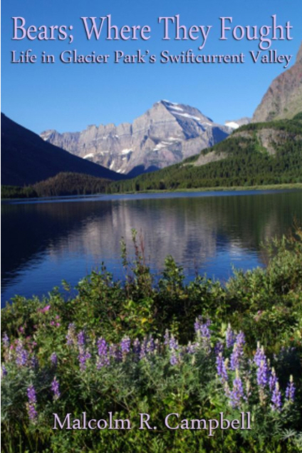
Bears; Where They Fought
Life in Glacier Park’s Swiftcurrent Valley
by
Malcolm R. Campbell
Copyright 2010
“Give a month at least to this precious reserve. The time will not be taken from the sum of your life. Instead of shortening, it will indefinitely lengthen it and will make you truly immortal. — John Muir, “Our National Parks,” 1901
“Far away in Montana, hidden from view by clustering mountain-peaks, lies an unmapped northwestern corner- the Crown of the Continent. The water from the crusted snowdrift which caps the peak of a lofty mountain there trickles into tiny rills, which hurry along north, south, east and west, and growing to rivers, at last pour their currents into three seas. From this mountain-peak the Pacific and the Arctic oceans and the Gulf of Mexico receive each its tribute. Here is a land of striking scenery.” — George Bird Grinnell, “The Century Magazine,” 1901
“…hereby dedicated and set aside as a public park or pleasure ground for the benefit and enjoyment of the people of the United States under the name of “The Glacier National Park;” … and for the care and protection of the fish and game within the boundaries thereof.” Enabling legislation establishing Glacier National Park May 11, 1910
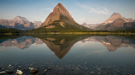
Swiftcurrent Creek – Barry Campbell photo
When Hudson’s Bay Company agent Hugh Monroe and a Piegan hunting party rode up the Íxikuoyi-yétahtai (Swiftcurrent Creek) into a U-shaped valley that would become part of Glacier National Park a half century later, they saw two male grizzly bears fighting next to two small lakes. They named the place Kyáiyoix ozitáizkahpi (Bears-Where-They-Fought-Lakes) because that’s what happened there and that’s how they would speak of it later when they told their stories.
A hiker following Glacier Route Three west into the valley from the plains along lateral moraines left behind when the valley glaciers melted off 8,000 years ago will hear no residual growls from those fighting bears. No sign marks the spot. The wise aspen, spruce and pine keep their counsel. On a quiet day, however, those walking alongside the relatively recent Lake Sherburne reservoir may hear the voice of grandfather rock whispering a secret: within the scope of geologic time, all rivers are new, and the men and women who follow them are as ephemeral as monarch butterflies on a summer afternoon.
From the perspective of Glacier National Park’s Proterozoic rock born in a great sea 1.6 billion years ago, the immortality man acquires here in the Shining Mountains comes through his stories. On the eastern side of the park, the oldest stories come from the Pikúni tribe of the Blackfeet Confederacy. Also known as the South Piegans, they fished, trapped and hunted in the mountains long before Europeans arrived on the continent, and their stories were part of a long-standing oral tradition before they were recorded and published by such writers as George Bird Grinnell (1849-1938) and James Willard Schultz (1859-1947).
Place Names Capture the Stories
Other stories—Pikúni and explorer alike—have been captured in the park’s place names. Twenty-two miles south of Lake Sherburne, Rising Wolf Mountain carries Hugh Monroe’s Blackfeet name. Monroe, some said, awoke like a wolf. His name, translated from the Blackfeet Mahkúyi-opuáhsin is “The way the wolf rises.” The view of both mountains and plains from the 9,505-foot summit is among the more spectacular in the park. Seven miles up Canyon Creek from Lake Sherburne, Mount Siyeh, from the Blackfeet Sáiyi (Mad Wolf) is named after an honored warrior.
George Bird Grinnell is often called the “father of Glacier National Park.” His name adorns a glacier on the eastern face of a narrow arête along the continental divide seven miles from Lake Sherburne. Like the park’s other existing Glaciers, Grinnell Glacier was born 4,000 years ago and reached its maximum size during the mid-1800s. While the glacier still moves an inch and a half per day, it’s shrunk to 35% of the size it was when Hugh Monroe saw it. Apikuni Mountain, next to Swiftcurrent Falls at the head of Lake Sherburne carries a revered tribal name (literally “spotted robe”). It was conferred on James Willard Schultz who, like Monroe, lived with the Piegans for many years.
Swiftcurrent Valley – NPS photo
The Piegan Nation Owned the Land
Charlie Howe, who homesteaded near Lake McDonald west of the continental divide in 1892, once said, “A man can find anything he wants in this region.” Men wanted riches in the Swiftcurrent Valley. But there was a snag. The riches lay hidden on Piegan land. There were incidents. Several Piegans were killed in the streets of a town on the Missouri River. The Piegans attacked freighters and settlers crossing Indian land. Long-time rancher Malcolm Clark was murdered even though his wife was a Piegan.
Sent to bring the offending Indians to justice, Major Eugene Baker attacked the wrong camp. At 8:00 a.m. on January 23, 1870, Baker’s troop swept through the camp of Isók-omahkan (Heavy Runner)—a friendly chief already fighting a small pox epidemic—and slaughtered 120 men and 53 women and children. The chief, killed while waving his identification papers in the air, is remembered now by the 8000-foot mountain alongside today’s Going-to-the-Sun Highway and by many stories. Baker is remembered for the “Baker Massacre.”
Buchholtz writes that, “the Baker Massacre, combined with a devastating smallpox epidemic and continuing white incursions, meant that the Blackfeet lost more than half their population, placed their social organization in deep decay, and left them utterly demoralized as a people.” The buffalo were gone by 1882 and starvation was rampant by 1883. While miners and prospectors could travel into Blackfeet land without resistance, they could not stake any legal claims.
After political pressure, money and arm-twisting were applied, the Piegan (usually referred to as Blackfeet) sold the mountain portion of their land for $1,500,000 in 1895. It was half of what they wanted, but they were resigned to losing it anyway. This “ceded strip” represents all of today’s Glacier National Park east of the continental divide. The Blackfeet reservation abuts the park’s eastern boundary at the foot of Lake Sherburne.
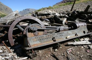
The ceded strip was declared “open” on April 15, 1898 and the rush of men surged up the Íxikuoyi-yétahtai Creek through the stair-step valley of paternoster lakes dreaming of a great Montana mining center. They felled trees, drilled for oil and built a mining town called Altyn at Kyáiyoix ozitáizkahpi in the mountain sheep lambing flats where Monroe saw the grizzlies fighting. Dead six years now, old Mahkúyi-opuáhsin (Rising Wolf) was spared the new vision for scenery he had been one of the first white men to see. They followed Canyon Creek seven miles along the foot of Píta Síxinam (named for Black Eagle who was wounded in the Baker Massacre) to a lake named Patáki (Carrier Woman). The present name of Píta Síxinam is Mt. Allen, for Cornelia Seward Allen, the granddaughter of Lincoln’s Secretary of State. The lake is now known as Cracker Lake either because it became the site of the Cracker Jack Mine or because some prospectors ate cheese and crackers there for lunch in 1897.
Mining Equipment at Cracker Lake – Wikipedia Photo
The Cracker Jack Mine was served by a road built over Cretaceous Rocks covered with glacial drift alongside a white water creek through a forest of pine, fir and spruce. Like the other mines within the ceded strip, the costly Cracker Jack failed. Thirty-five years later, floods destroyed the road.
Miners moved west from Altyn past Lake McDermott, which they named for a lumberman and mine claimant, into a region where the valley split into multiple branches. The Piegan called the area Óhpskunakáxi (Waterfalls). Following the creeks, one group searched for minerals at the horn-shaped Mt. Wilbur that today forms one of Glacier Park’s most sought-after postcard views across the lake from Many Glacier Hotel. Though Grinnell renamed this mountain in 1885 for one of his publishing partners, the Piegan remembered one of their warriors Isokwi-awótan (Heavy Shield) in the flat-faced mountain. Like the adjacent Pinnacle Wall arête, Wilbur has a conspicuous diorite sill, a black band of igneous rock that intruded between sedimentary layers.
Prospectors also followed a branch of the valley that led toward Grinnell Glacier over the forested moraine that contains Lake Nitáki (Lone Woman) nestled within a spruce and fir forest. Today, the lake is named “Josephine.” Many Glacier Hotel visitors making the six mile hike to Grinnell Glacier along the southern slopes of Grinnell Point often notice the old entrance to the Josephine Copper Mine. Strong hikers and beginning climbers can reach the mine above the broken cliffs and talus slopes with some careful scrambling. In “Place Names of Glacier/Waterton National Parks,” author Jack Holterman said he couldn’t be sure whether the lake was named after the mine, prospector Dan Doody’s wife Josephine or a miner’s mule.
Mining Expected to be Long Term
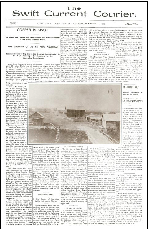
Courier – Man in Glacier – NPS photo
In its one and only issue, Altyn’s Swift Current Courier on September 1, 1900 observed the high-pitched activity within the ceded strip and headlined: “NO DOUBT ABOUT THE PERMANCY AND PRODUCTIVENESS OF THE SWIFT CURRENT MINES.” And also: ‘THE GROWTH OF ALTYN ASSURED.” The stories growing out of the valley chronicled during 1900 by the Acantha, in nearby Dupuyer include:
February 22 – Swift Current will have a railroad inside of six months.
March 3 – The road up to Swift Current in its present condition has been known to make a preacher curse, and I have my opinion of the man who makes the trip over this road (!) without breaking the 3rd commandment or perhaps all ten of them.
March 22 – It’s been rumored that a vein of coal has been discovered, but nothing definite can be learned.
March 29 – ABOUT THE CEDED STRIP. There is no limit to the possibilities in this new country when all the restrictions have been removed. This is the verdict of all men, and some women who have looked the ground over intelligently, intelligently, and this reminds me that the Cattle Queen was right up to the front when the strip opened. She forded and swam her horse across streams which turned back more than one man.
April 12 – Sherburne Morse has visited the camp and says that he is well pleased with the prospects of the camp. Sherb does not say much, but his money talks.
May 3– A post office has been established at Harris Flat, and the government is advertising for bids for service at Blackfoot. The new office is called Altyn. [The Great Northern Railway, connecting Chicago to Seattle via Minneapolis, Minneapolis, had a station at Blackfoot for the delivery of freight.]
May 10 – The Swift Current Butchering Company have secured a lot at the mouth of Windy Creek, on the Crucible claim, where they have erected a first class plant…Mr. Wilson and a crew of men are trying to blow the bottom out of Swift Current Falls…Hold onto your quartz claims, for in a year you can get your own price.
May 24 – The Swift Current road is in terrible condition, and unless a large amount of work is done on it, it will be impossible to get machinery in. A six-horse outfit is stalled on the road, the wagon being in the mud above the hubs and two wheel horses down on their sides.
June 7 – Altyn, formerly known as Harrisville, is still in the boom, and several buildings have been erected…The saw mill has been erected and is ready to begin operations. It has been erected on the north shore of McDermott Lake…The Swift Current Butchering Company has been doing well of late…A barber could do well here, for such a man is in demand…The Sherburne residence is completed and ready for occupation. [This residence was owned by Joseph Sherburne for whom the two lakes (and the current reservoir) were ultimately named. He owned a large general store in nearby Browning and drilled the first oil well in the Swiftcurrent Valley.]
June 28 – Swift Current is about to have a “washie” house. John Chinaman is in camp making arrangements…The Lippincott boys are erecting a good sized building on the main street of Altyn…Mr. Thompson has been clearing a lot on the west side of Main Street, where partners from Kalispell intend to erect a general merchandize store…The Josephine Mine continues in richness, and is now in the district…A building is being erected on the first lot which will be used for a saloon…Mr. Sherburne of Browning, and a couple of gentlemen from Minneapolis, are in camp.
July 6 – A few good sober carpenters, and experienced quartz miners can find work here…Two gin mills going up—resulting in nearly all of Mr. Esler’s men going on a tear, and causing him to warm up under the collar.
July 26 – Old Glory was raised over the saloon last Friday, the first flag raised in the camp. • July 11 – The 50-ton concentrator will be erected in the Spring, and from that time forward, the activity will be great.
August 16 – Heavy shipments of mining machinery continue to arrive at Blackfoot and are being freighted to Swift Current where great activity prevails at present. Ere long the sound of the steam whistle and the roar of the concentrator will be heard in the region and ye Copper King will say “Come and take something. My dream is realized, so who cares for expense?”
Joseph Sherburne’s well produced a small amount of oil, the first in Montana. Substantial oil and gas would be found 72 miles east along the “Montana Hi Line” rail corridor at Cut Bank. The town was once known as the oil capital of Montana. Swiftcurrent Valley’s Precambrian sedimentary formations contained copper, but the amounts fell far short of promoters’ expectations. While one writer on the Dupuyer Acantha used the pseudonym “Copper King,” the real king copper was “The Hill” in the notorious boom town of Butte 276 miles south of Altyn.
Even at 1,300 feet into the mountain, the Cracker Jack Mine tunnel never produced much ore, and the heavy equipment freighted to the site was left behind where it would be noted on modern trail maps as relics from another age. Some of the claims would exist for a half century, including the one where the National Park Service entry station now sits on the road into the Swiftcurrent Valley. Some prospectors had already given up and headed for the Klondike before Altyn’s post office arrived. Only the most stubborn dreamers were still there when the post office closed in 1906.
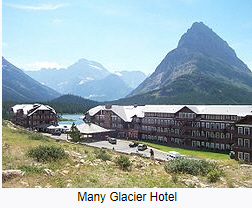
While Jim Hill’s Great Northern Railway never built a branch line into the valley, the railroad did in fact establish a direct presence there for 43 years, a presence that lasts in wood, stone and spirit to this day. Glacier National Park’s primary hotels and chalets were built by the railroad as tourist destinations for rail travelers. Under its Glacier Park Hotel Company subsidiary, Great Northern built the Swiss-style, 240-room Many Glacier Hotel on Lake McDermott between 1914 and 1917 a few years after the park was established. In the early years, most of the seasonal employees were hired at the company’s headquarters in Minnesota and traveled to the park over the “Empire Builder” route in a staff rail car.
In 1915, the last time James Willard Schultz traveled into the valley, the Piegans with him asked about him the place names. Who is this McDermott? The lake should be named Jealous Woman after the old story. Are the men behind these names powerful chiefs? Schultz confessed that he had never heard of most of them. The party thought even the wild animals looked changed, domesticated for the visitors in some way. McDermott Lake would later be given the long-time local name of Swiftcurrent.
Great Northern logo and map – Wikipedia photo
Legacy of the Great Northern Railway
The Great Northern (now BNSF) entered the valley in force, building the hotel out of local materials. They erected a saw mill on site and even now, evidence of the old logging road to Lake Josephine still exists. While the railroad didn’t like rail passengers seeing Indians along its “Hi Line” right of way, the company promoted the Blackfeet as the “Glacier Park Tribe” and sent them on rail excursions around the country to publicize the park. Great Northern, a predecessor road of today’s huge Burlington Northern Sante Fe, sold its hotel subsidiary in 1960. A half century later, Many Glacier Hotel remains the most popular in the park—a National Register District rather than a mining district.
Between 1914 and 1921 the Bureau of Reclamation constructed a dam near Joseph Sherburne’s former oil drilling site. The 107-foot high compacted earth fill structure created the 242,000 cubic yard reservoir as we know it today. As part of Milk River Project, Lake Sherburne’s water helps irrigate 121,000 acres of land in north central Montana. Water destined for the reservoir originates near Piegan Pass and flows down Cataract Creek to meet the water from Grinnell Glacier in Lake Josephine. Lake Josephine’s turquoise color comes from the “rock flour” in the glacial water. At Swiftcurrent Lake, the water from Lake Josephine merges with water from Swiftcurrent Glacier, Iceberg Lake, and Ptarmigan Lake.
Glacier National Park’s Lewis Thrust Fault, where hard 1.6 billion-year-old limestone formations were shoved by crustal forces eastward over the softer 70-million-year-old Cretaceous-age shale, is visible above Lake Sherburne at Swiftcurrent Falls. The fault is also visible on the eastern face of Mt. Wynn on the far side of the reservoir.
While some have imagined this over-thrusting as a violent 50-mile-long stone toboggan ride, the event occurred over millions of years. Along Glacier National Park’s eastern boundary, the mountains don’t have deep roots. In his “A Natural History Guide: Glacier National Park,” David Rockwell writes that the mountains “that stand like a parapet against eastern Montana, are rootless in the sense that they are not anchored, not sunk into the earth like most mountains. Rather they perch on top of it, unconnected except by juxtaposition to the rock beneath.”
Since geologist Bailey Willis discovered the thrust fault in 1901 during Altyn’s boom, the mining geologists following Canyon Creek through the valley between Mt. Allen and Mt. Wynn were probably aware of its significance. At the time, Mt Wynn was called Mt. Altyn, supposedly honoring prospector Jim Harris’ horse. The name was changed to Mt. Wynn in 1927, the same year Mt. McDermott was renamed Mt. Alytn.
The water of lake Sherburne now covers the oil well drill sites and the remnants of the town of Altyn that have, like changing place names in changing times, been shifted from the worlds of industry and commerce to the world of archeology. The forest around the two small lakes where Hugh Monroe saw the bears fighting to the death was logged off before the town of Altyn died. Its remnants are under water, too.
Most tourists visiting Swiftcurrent Valley have never heard of the town of Altyn 104 years now after its passing. The Kyáiyoix ozitáizkahpi, the Bears-Where-They-Fought-Lakes, have faded deeper into the past and so, too, the Blackfeet place names. Hikers leaving Many Glacier Hotel for the five mile hike to Morning Eagle falls are probably not aware the falls is named after a famous warrior Apinákui-Pita who was said to have had power over ghosts. Climbers following Apikuni Creek from the shore of Lake Sherburne to Natahki Lake may guess the name is a Blackfeet word. The fact that it’s the name of James Willard Schultz’s wife who was crippled for life from wounds received in the Baker Massacre is not noted in maps and climber’s guidebooks.
The valley’s stories stack up like the park’s Shepard, Snowslip, Helena, Empire, Grinnell, Appekunny, Prichard and Altyn rock formations. Memories of the men, women and children lost or wounded in the Baker Massacre on the Marias River stand out in the historical record as sharply as the stunning red argillites of the Grinnell formation. Stories of boom town gin mills and fighting bears pale into inconsequential obscurity like the light, buff colored Altyn formation dolomites and limestones. However, those looking closely will find ripple marks in both the Altyn rock and the fading memories.
Meriwether Lewis was the first man to specifically apply the old descriptive phrase “Shining Mountains” to the mountains of Montana’s Glacier National Park and Alberta’s adjoining Waterton Lakes National Park. The history of the region after the Lewis and Clark expedition (1804-1806) enhances our understanding of Glacier National Park in its centennial year—a birthday 1.6 billion years in the making. But it is our personal stories, borne out of direct experience, that provide our psychological and spiritual connections to such places as Swiftcurrent Creek and Grinnell Glacier.
Eighty-five years ago, National Park Service director Stephen Mather lost his patience with the Great Northern Railway. The GN’s long-abandoned sawmill next to Many Glacier Hotel was a dangerous eyesore, and the railroad couldn’t find time to dismantle it. Without telling anyone, Mather rigged the derelict building with explosives; then he invited hotel guests out on to the large back porch off the lobby to watch and blew up the sawmill. Mather made his point and put on quite a show for his tourists in 1925. In the parlance of “Bears, Where they Fought,” the story about “Sawmill, Where It Exploded” was something to write home about.
Seventy-seven years ago, a sheep-herder’s unattended fire burned off the forest on Boulder Ridge on the south side of Lake Sherburne. The effects of the fire can still be found today. Those living and working around Swiftcurrent Valley wouldn’t forget the “Sheep, Where They Ran” story of 1933.
Seventy-six years ago, Franklin D. Roosevelt became the first and only sitting President to visit Swiftcurrent Valley and other locations throughout the park. The Presidential party rode in the now-legendary White Motor Company Red Buses with the tops town. FDR had lunch at Many Glacier Hotel and then continued on to Two Medicine Chalet where the he gave a fireside chat in which he said, “Perhaps I can best express to you my thrill and delight by saying that I wish every American young and old, could have been with me today.” The National Park Service and concessioner employees who served the President on August 5, 1934 had a once-in-a-lifetime experience that might be styled, perhaps, as “The President, Where He Ate.”
Seventy-four years ago, the month of August was unkind It had been a dry summer. On August 18, lightning started a fire on the Glacier Wall near Heaven’s Peak. Multiple fire crews were dispatched during succeeding weeks, but the winds were high, the fire was stubborn, and its location was nearly inaccessible. Consequently, it jumped the continental divide at Swiftcurrent Pass and raced down the valley past Mt. Wilbur, reaching Many Glacier Hotel in less than an hour. Lake Sherburne formed a natural barrier, and the Heaven’s Peak Fire stopped where Altyn once thrived. On the night of August 31, 1936, seasonal employees manning fire hoses kept the hotel wet enough to save it, though four chalets were lost. According to John Hagen’s “History of Many Glacier Hotel,” the manager sent a telegram to the railroad, saying “WE HAVE SAVED THE HOTEL.” He received a one-word response from the Great Northern headquarters: “WHY?” The hotels were not a profitable enterprise, though employees would spin yarns about “Many, How We Saved It” for years.
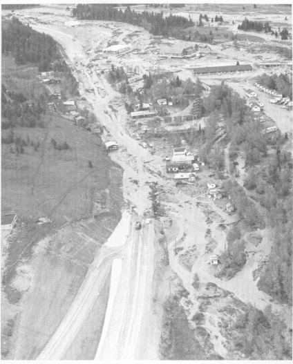
Damage at St. Mary – Montana Highway Department photo
The Great Flood of 1964
Forty-six years ago, heavy rains and a heavy snowpack in the mountains of Northwest Montana combined to create a flood that is still considered the state’s largest natural disaster. Thirty-four counties, including Glacier County, were declared a disaster area. The Flathead, Clark Fork, Blackfoot, Milk, Marias, Teton, Sun and Missouri rivers were involved as were Swiftcurrent and numerous other creeks within the park. Roads and structures were damaged or destroyed throughout the park. Swiftcurrent Lake inundated Many Glacier Hotel’s lake-level rooms and then left them filled with mud. Glacier Road Three, on Swiftcurrent Ridge above Lake Sherburne, was washed out in two places, one at Windy Creek where, just sixty-three years earlier, the Swift Current Butchering Company operated a first class plant. During the first days of June, 1964 college-student employees from around the country had enough yarns about “Flood, How We Survived It” to fill a stack of postcards of the surrounding vistas captured on sunnier days.
Thirty-Five years ago, the rain was so heavy that Many Glacier Hotel’s roof sprung multiple leaks, and again Swiftcurrent Lake filled the lower level rooms with water. The road was washed out and the hotel was closed for ten days. Employees working at the hotel on June 19, 1975 would write home—when mail service resumed—about how cold the lake water was and how cold the guest rooms were after many days with no boiler and no heat. The incoming guests probably wrote home about, “Extra Blankets, How We Begged For Them.”
Stories are a natural component of everyone’s experience in the valley where Hugh Monroe and the Piegan hunting party saw the bears fighting in another era. Whether based on fact or caprice, neither the reliable accounts nor the tall tales can be truly separated from the place any more than the narrow arêtes and cirque lakes, grizzly bears and Columbian ground squirrels, ospreys and golden eagles, Englemann Spruce and Subalpine Fir, or the evergreen kinnikinnik vines and yellow-tufted beargrass. Our stories come from hikes, climbs, campfires, animals, weather, hotel accommodations, tour bus trips, launch rides, trail horse rides, and the garden-variety vicissitudes of a wild place mixed with tourists.
Henry David Thoreau suggested an ideal that has been hard to meet when he wrote that “In wilderness is the preservation of the world.” The value of safeguarding natural ecosystems is so vital, scenery actually does put food on the table while maintaining our lives in ways that surpass our understanding of earth as a multi-creatured organism.
Ironically, as we figuratively sang “Happy Birthday” to the park in 2010, others literally wanted to spoil the party. Often called the most endangered national park in the system, Glacier was threatened by a proposed strip mine in British Columbia in 1985. While proposal was defeated, a prospective coalbed methane field in British Columbia looms across the border.
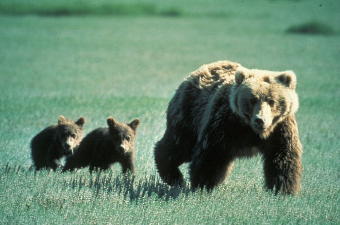
While Altyn will always lurk beneath the surface, grizzly bears are also there as mythic symbols of an epic story far greater than a land ethic focused on the preservation of habitats and their interface with modern civilization. True stories are always personal. Everyone who follows Íxikuoyi-yétahta, Swiftcurrent Creek, past Kyáiyoix ozitáizkahpi where the bears fought to its source at the top of the backbone of the world receives Earth’s greatest gift—the transcendent renewal of spirit.
Grizzly Bear with Cubs – NPS photo
The research assistance for this essay provided by Montana Historical Society reference librarian Zoe Ann Stoltz and Glacier National Park museum curator Deirdre Shaw is greatly appreciated. Any errors and omissions belong to the author.
Calendar time for such phrases as “XX years ago” is calculated based on the original publication date of this essay in 2010.
I worked as an editorial assistant on the first edition (1983) of this book that uses photographs and a fold-out map to show ripple marks and fossil evidence of ancient times in the rock formations along Glacier National Park’s Going-to-the-Sun Road. I’m happy to see that the book’s new edition (2018) by Teagan Tomlin maintains the best features of the original while adding new photographs and updates.
From the Publisher
With this newly updated colorful and lively guide, Glacier National Park visitors can take a self-guided tour of the fascinating geological events that created the park’s majestic scenery. Complete with an easy-to-read map that offers a three-dimensional perspective on the area’s geology. Geology Along Going-to-the-Sun Road gives lay readers and geologists alike a unique opportunity to get behind-the-scenery at 21 stops along this famous highway.
The Park’s red bus tours mention the large scale geology of the park from its cirque lakes to its glacier-carved arêtes. But they don’t usually mention the smaller evidence of the past within the rock itself. This is a wonderful guide for those traveling Sun Road in their cars or on their bicycles. Or, on foot.
The book includes information about the park’s rock formations, the Lewis thrust fault, and the actions of weathering and glaciation over time.
 Those of us who became addicted to Glacier National Park over half a century ago, learned more about the park by reading books and monographs published by the former Glacier Natural History Association, for which I was a volunteer, that drew on the expertise of those whom I consider the first generation of modern-day park historians including Jack Holterman, Clyde Lockwood, Curt Buchholtz, Michael J. Ober, and others. For today’s generation, I should add David R. Butler (Fire Lookouts of Glacier National Park) to that evolving list for providing another readable chapter to the park’s knowledge with the current volume released by Arcadia Publishing in February.
 Malcolm R. Campbell writes fiction set in the park. Unfortunately, his only nonfiction contribution is out of print.
![The Weight of Night: A Novel of Suspense (Glacier Mystery Series Book 3) by [Christine Carbo]](https://m.media-amazon.com/images/I/41Oxu8PCBoL.jpg) In a land sculpted by glaciers, the forest is on fire. Thick smoke chokes the mountain air and casts an apocalyptic glow over the imposing peaks and vistas of Montana’s Glacier National Park. When firefighters are called in to dig firebreaks near the small town bordering the park, a crew member is shocked to unearth a shallow grave containing human remains.
In a land sculpted by glaciers, the forest is on fire. Thick smoke chokes the mountain air and casts an apocalyptic glow over the imposing peaks and vistas of Montana’s Glacier National Park. When firefighters are called in to dig firebreaks near the small town bordering the park, a crew member is shocked to unearth a shallow grave containing human remains.
 Christine Carbo
 The national parks are suffering a similar death, one in which most people consider humans to be the most invasive species with the once pristine preserve. Years ago, Glacier National Park was considered the most threatened park in the NPS system, primarily from air and water polution that arose outside its borders. Now the new threat comes from within as the NPS continues to resist putting a cap on the number of visitors allowed each year.
 When I first explored the mountains of Glacier National Park, “time let me hail and climb golden in the heydays of his eyes.” I thought those trails and those days would go on forever even though I had read the Dylan Thomas poem many times and knew how it ended. Even though grandparents are around us when we are young, we still think we will always be young and, that if we won’t, old age is eons away in a future too far away to fathom.


 The name of the novel comes from the 20th major arcana card in the Thoth Tarot deck. According to