Note: This somewhat lengthy post about Glacier National Park’s Swiftcurrent Valley first appeared in a now-out-of-print anthology called “Nature’s Gifts,” published in 2010 in paperback. For a short time thereafter the essay was available as a Kindle single. I hope those who visit and/or work in the park will still find the information interesting. – MRC

Bears; Where They Fought
Life in Glacier Park’s Swiftcurrent Valley
by
Malcolm R. Campbell
Copyright 2010
“Give a month at least to this precious reserve. The time will not be taken from the sum of your life. Instead of shortening, it will indefinitely lengthen it and will make you truly immortal. — John Muir, “Our National Parks,” 1901
“Far away in Montana, hidden from view by clustering mountain-peaks, lies an unmapped northwestern corner- the Crown of the Continent. The water from the crusted snowdrift which caps the peak of a lofty mountain there trickles into tiny rills, which hurry along north, south, east and west, and growing to rivers, at last pour their currents into three seas. From this mountain-peak the Pacific and the Arctic oceans and the Gulf of Mexico receive each its tribute. Here is a land of striking scenery.” — George Bird Grinnell, “The Century Magazine,” 1901
“…hereby dedicated and set aside as a public park or pleasure ground for the benefit and enjoyment of the people of the United States under the name of “The Glacier National Park;” … and for the care and protection of the fish and game within the boundaries thereof.” Enabling legislation establishing Glacier National Park May 11, 1910

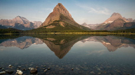
When Hudson’s Bay Company agent Hugh Monroe and a Piegan hunting party rode up the Íxikuoyi-yétahtai (Swiftcurrent Creek) into a U-shaped valley that would become part of Glacier National Park a half century later, they saw two male grizzly bears fighting next to two small lakes. They named the place Kyáiyoix ozitáizkahpi (Bears-Where-They-Fought-Lakes) because that’s what happened there and that’s how they would speak of it later when they told their stories.
A hiker following Glacier Route Three west into the valley from the plains along lateral moraines left behind when the valley glaciers melted off 8,000 years ago will hear no residual growls from those fighting bears. No sign marks the spot. The wise aspen, spruce and pine keep their counsel. On a quiet day, however, those walking alongside the relatively recent Lake Sherburne reservoir may hear the voice of grandfather rock whispering a secret: within the scope of geologic time, all rivers are new, and the men and women who follow them are as ephemeral as monarch butterflies on a summer afternoon.
From the perspective of Glacier National Park’s Proterozoic rock born in a great sea 1.6 billion years ago, the immortality man acquires here in the Shining Mountains comes through his stories. On the eastern side of the park, the oldest stories come from the Pikúni tribe of the Blackfeet Confederacy. Also known as the South Piegans, they fished, trapped and hunted in the mountains long before Europeans arrived on the continent, and their stories were part of a long-standing oral tradition before they were recorded and published by such writers as George Bird Grinnell (1849-1938) and James Willard Schultz (1859-1947).
Place Names Capture the Stories
Other stories—Pikúni and explorer alike—have been captured in the park’s place names. Twenty-two miles south of Lake Sherburne, Rising Wolf Mountain carries Hugh Monroe’s Blackfeet name. Monroe, some said, awoke like a wolf. His name, translated from the Blackfeet Mahkúyi-opuáhsin is “The way the wolf rises.” The view of both mountains and plains from the 9,505-foot summit is among the more spectacular in the park. Seven miles up Canyon Creek from Lake Sherburne, Mount Siyeh, from the Blackfeet Sáiyi (Mad Wolf) is named after an honored warrior.
George Bird Grinnell is often called the “father of Glacier National Park.” His name adorns a glacier on the eastern face of a narrow arête along the continental divide seven miles from Lake Sherburne. Like the park’s other existing Glaciers, Grinnell Glacier was born 4,000 years ago and reached its maximum size during the mid-1800s. While the glacier still moves an inch and a half per day, it’s shrunk to 35% of the size it was when Hugh Monroe saw it. Apikuni Mountain, next to Swiftcurrent Falls at the head of Lake Sherburne carries a revered tribal name (literally “spotted robe”). It was conferred on James Willard Schultz who, like Monroe, lived with the Piegans for many years.
The Piegan Nation Owned the Land
Charlie Howe, who homesteaded near Lake McDonald west of the continental divide in 1892, once said, “A man can find anything he wants in this region.” Men wanted riches in the Swiftcurrent Valley. But there was a snag. The riches lay hidden on Piegan land. There were incidents. Several Piegans were killed in the streets of a town on the Missouri River. The Piegans attacked freighters and settlers crossing Indian land. Long-time rancher Malcolm Clark was murdered even though his wife was a Piegan.
Sent to bring the offending Indians to justice, Major Eugene Baker attacked the wrong camp. At 8:00 a.m. on January 23, 1870, Baker’s troop swept through the camp of Isók-omahkan (Heavy Runner)—a friendly chief already fighting a small pox epidemic—and slaughtered 120 men and 53 women and children. The chief, killed while waving his identification papers in the air, is remembered now by the 8000-foot mountain alongside today’s Going-to-the-Sun Highway and by many stories. Baker is remembered for the “Baker Massacre.”
Buchholtz writes that, “the Baker Massacre, combined with a devastating smallpox epidemic and continuing white incursions, meant that the Blackfeet lost more than half their population, placed their social organization in deep decay, and left them utterly demoralized as a people.” The buffalo were gone by 1882 and starvation was rampant by 1883. While miners and prospectors could travel into Blackfeet land without resistance, they could not stake any legal claims.
After political pressure, money and arm-twisting were applied, the Piegan (usually referred to as Blackfeet) sold the mountain portion of their land for $1,500,000 in 1895. It was half of what they wanted, but they were resigned to losing it anyway. This “ceded strip” represents all of today’s Glacier National Park east of the continental divide. The Blackfeet reservation abuts the park’s eastern boundary at the foot of Lake Sherburne.
The ceded strip was declared “open” on April 15, 1898 and the rush of men surged up the Íxikuoyi-yétahtai Creek through the stair-step valley of paternoster lakes dreaming of a great Montana mining center. They felled trees, drilled for oil and built a mining town called Altyn at Kyáiyoix ozitáizkahpi in the mountain sheep lambing flats where Monroe saw the grizzlies fighting. Dead six years now, old Mahkúyi-opuáhsin (Rising Wolf) was spared the new vision for scenery he had been one of the first white men to see. They followed Canyon Creek seven miles along the foot of Píta Síxinam (named for Black Eagle who was wounded in the Baker Massacre) to a lake named Patáki (Carrier Woman). The present name of Píta Síxinam is Mt. Allen, for Cornelia Seward Allen, the granddaughter of Lincoln’s Secretary of State. The lake is now known as Cracker Lake either because it became the site of the Cracker Jack Mine or because some prospectors ate cheese and crackers there for lunch in 1897.

The Cracker Jack Mine was served by a road built over Cretaceous Rocks covered with glacial drift alongside a white water creek through a forest of pine, fir and spruce. Like the other mines within the ceded strip, the costly Cracker Jack failed. Thirty-five years later, floods destroyed the road.
Miners moved west from Altyn past Lake McDermott, which they named for a lumberman and mine claimant, into a region where the valley split into multiple branches. The Piegan called the area Óhpskunakáxi (Waterfalls). Following the creeks, one group searched for minerals at the horn-shaped Mt. Wilbur that today forms one of Glacier Park’s most sought-after postcard views across the lake from Many Glacier Hotel. Though Grinnell renamed this mountain in 1885 for one of his publishing partners, the Piegan remembered one of their warriors Isokwi-awótan (Heavy Shield) in the flat-faced mountain. Like the adjacent Pinnacle Wall arête, Wilbur has a conspicuous diorite sill, a black band of igneous rock that intruded between sedimentary layers.
Prospectors also followed a branch of the valley that led toward Grinnell Glacier over the forested moraine that contains Lake Nitáki (Lone Woman) nestled within a spruce and fir forest. Today, the lake is named “Josephine.” Many Glacier Hotel visitors making the six mile hike to Grinnell Glacier along the southern slopes of Grinnell Point often notice the old entrance to the Josephine Copper Mine. Strong hikers and beginning climbers can reach the mine above the broken cliffs and talus slopes with some careful scrambling. In “Place Names of Glacier/Waterton National Parks,” author Jack Holterman said he couldn’t be sure whether the lake was named after the mine, prospector Dan Doody’s wife Josephine or a miner’s mule.
Mining Expected to be Long Term
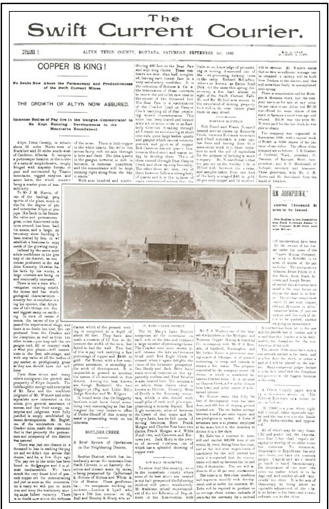
In its one and only issue, Altyn’s Swift Current Courier on September 1, 1900 observed the high-pitched activity within the ceded strip and headlined: “NO DOUBT ABOUT THE PERMANCY AND PRODUCTIVENESS OF THE SWIFT CURRENT MINES.” And also: ‘THE GROWTH OF ALTYN ASSURED.” The stories growing out of the valley chronicled during 1900 by the Acantha, in nearby Dupuyer include:
- February 22 – Swift Current will have a railroad inside of six months.
- March 3 – The road up to Swift Current in its present condition has been known to make a preacher curse, and I have my opinion of the man who makes the trip over this road (!) without breaking the 3rd commandment or perhaps all ten of them.
- March 22 – It’s been rumored that a vein of coal has been discovered, but nothing definite can be learned.
- March 29 – ABOUT THE CEDED STRIP. There is no limit to the possibilities in this new country when all the restrictions have been removed. This is the verdict of all men, and some women who have looked the ground over intelligently, intelligently, and this reminds me that the Cattle Queen was right up to the front when the strip opened. She forded and swam her horse across streams which turned back more than one man.
- April 12 – Sherburne Morse has visited the camp and says that he is well pleased with the prospects of the camp. Sherb does not say much, but his money talks.
- May 3– A post office has been established at Harris Flat, and the government is advertising for bids for service at Blackfoot. The new office is called Altyn. [The Great Northern Railway, connecting Chicago to Seattle via Minneapolis, Minneapolis, had a station at Blackfoot for the delivery of freight.]
- May 10 – The Swift Current Butchering Company have secured a lot at the mouth of Windy Creek, on the Crucible claim, where they have erected a first class plant…Mr. Wilson and a crew of men are trying to blow the bottom out of Swift Current Falls…Hold onto your quartz claims, for in a year you can get your own price.
- May 24 – The Swift Current road is in terrible condition, and unless a large amount of work is done on it, it will be impossible to get machinery in. A six-horse outfit is stalled on the road, the wagon being in the mud above the hubs and two wheel horses down on their sides.
- June 7 – Altyn, formerly known as Harrisville, is still in the boom, and several buildings have been erected…The saw mill has been erected and is ready to begin operations. It has been erected on the north shore of McDermott Lake…The Swift Current Butchering Company has been doing well of late…A barber could do well here, for such a man is in demand…The Sherburne residence is completed and ready for occupation. [This residence was owned by Joseph Sherburne for whom the two lakes (and the current reservoir) were ultimately named. He owned a large general store in nearby Browning and drilled the first oil well in the Swiftcurrent Valley.]
- June 28 – Swift Current is about to have a “washie” house. John Chinaman is in camp making arrangements…The Lippincott boys are erecting a good sized building on the main street of Altyn…Mr. Thompson has been clearing a lot on the west side of Main Street, where partners from Kalispell intend to erect a general merchandize store…The Josephine Mine continues in richness, and is now in the district…A building is being erected on the first lot which will be used for a saloon…Mr. Sherburne of Browning, and a couple of gentlemen from Minneapolis, are in camp.
- July 6 – A few good sober carpenters, and experienced quartz miners can find work here…Two gin mills going up—resulting in nearly all of Mr. Esler’s men going on a tear, and causing him to warm up under the collar.
- July 26 – Old Glory was raised over the saloon last Friday, the first flag raised in the camp. • July 11 – The 50-ton concentrator will be erected in the Spring, and from that time forward, the activity will be great.
- August 16 – Heavy shipments of mining machinery continue to arrive at Blackfoot and are being freighted to Swift Current where great activity prevails at present. Ere long the sound of the steam whistle and the roar of the concentrator will be heard in the region and ye Copper King will say “Come and take something. My dream is realized, so who cares for expense?”
Joseph Sherburne’s well produced a small amount of oil, the first in Montana. Substantial oil and gas would be found 72 miles east along the “Montana Hi Line” rail corridor at Cut Bank. The town was once known as the oil capital of Montana. Swiftcurrent Valley’s Precambrian sedimentary formations contained copper, but the amounts fell far short of promoters’ expectations. While one writer on the Dupuyer Acantha used the pseudonym “Copper King,” the real king copper was “The Hill” in the notorious boom town of Butte 276 miles south of Altyn.
Even at 1,300 feet into the mountain, the Cracker Jack Mine tunnel never produced much ore, and the heavy equipment freighted to the site was left behind where it would be noted on modern trail maps as relics from another age. Some of the claims would exist for a half century, including the one where the National Park Service entry station now sits on the road into the Swiftcurrent Valley. Some prospectors had already given up and headed for the Klondike before Altyn’s post office arrived. Only the most stubborn dreamers were still there when the post office closed in 1906.
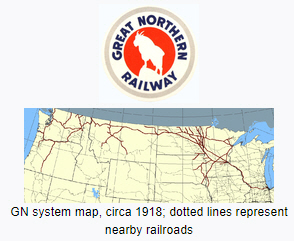
While Jim Hill’s Great Northern Railway never built a branch line into the valley, the railroad did in fact establish a direct presence there for 43 years, a presence that lasts in wood, stone and spirit to this day. Glacier National Park’s primary hotels and chalets were built by the railroad as tourist destinations for rail travelers. Under its Glacier Park Hotel Company subsidiary, Great Northern built the Swiss-style, 240-room Many Glacier Hotel on Lake McDermott between 1914 and 1917 a few years after the park was established. In the early years, most of the seasonal employees were hired at the company’s headquarters in Minnesota and traveled to the park over the “Empire Builder” route in a staff rail car.
In 1915, the last time James Willard Schultz traveled into the valley, the Piegans with him asked about him the place names. Who is this McDermott? The lake should be named Jealous Woman after the old story. Are the men behind these names powerful chiefs? Schultz confessed that he had never heard of most of them. The party thought even the wild animals looked changed, domesticated for the visitors in some way. McDermott Lake would later be given the long-time local name of Swiftcurrent.
Legacy of the Great Northern Railway
The Great Northern (now BNSF) entered the valley in force, building the hotel out of local materials. They erected a saw mill on site and even now, evidence of the old logging road to Lake Josephine still exists. While the railroad didn’t like rail passengers seeing Indians along its “Hi Line” right of way, the company promoted the Blackfeet as the “Glacier Park Tribe” and sent them on rail excursions around the country to publicize the park. Great Northern, a predecessor road of today’s huge Burlington Northern Sante Fe, sold its hotel subsidiary in 1960. A half century later, Many Glacier Hotel remains the most popular in the park—a National Register District rather than a mining district.
Between 1914 and 1921 the Bureau of Reclamation constructed a dam near Joseph Sherburne’s former oil drilling site. The 107-foot high compacted earth fill structure created the 242,000 cubic yard reservoir as we know it today. As part of Milk River Project, Lake Sherburne’s water helps irrigate 121,000 acres of land in north central Montana. Water destined for the reservoir originates near Piegan Pass and flows down Cataract Creek to meet the water from Grinnell Glacier in Lake Josephine. Lake Josephine’s turquoise color comes from the “rock flour” in the glacial water. At Swiftcurrent Lake, the water from Lake Josephine merges with water from Swiftcurrent Glacier, Iceberg Lake, and Ptarmigan Lake.
Glacier National Park’s Lewis Thrust Fault, where hard 1.6 billion-year-old limestone formations were shoved by crustal forces eastward over the softer 70-million-year-old Cretaceous-age shale, is visible above Lake Sherburne at Swiftcurrent Falls. The fault is also visible on the eastern face of Mt. Wynn on the far side of the reservoir.
While some have imagined this over-thrusting as a violent 50-mile-long stone toboggan ride, the event occurred over millions of years. Along Glacier National Park’s eastern boundary, the mountains don’t have deep roots. In his “A Natural History Guide: Glacier National Park,” David Rockwell writes that the mountains “that stand like a parapet against eastern Montana, are rootless in the sense that they are not anchored, not sunk into the earth like most mountains. Rather they perch on top of it, unconnected except by juxtaposition to the rock beneath.”
Since geologist Bailey Willis discovered the thrust fault in 1901 during Altyn’s boom, the mining geologists following Canyon Creek through the valley between Mt. Allen and Mt. Wynn were probably aware of its significance. At the time, Mt Wynn was called Mt. Altyn, supposedly honoring prospector Jim Harris’ horse. The name was changed to Mt. Wynn in 1927, the same year Mt. McDermott was renamed Mt. Alytn.
The water of lake Sherburne now covers the oil well drill sites and the remnants of the town of Altyn that have, like changing place names in changing times, been shifted from the worlds of industry and commerce to the world of archeology. The forest around the two small lakes where Hugh Monroe saw the bears fighting to the death was logged off before the town of Altyn died. Its remnants are under water, too.
Most tourists visiting Swiftcurrent Valley have never heard of the town of Altyn 104 years now after its passing. The Kyáiyoix ozitáizkahpi, the Bears-Where-They-Fought-Lakes, have faded deeper into the past and so, too, the Blackfeet place names. Hikers leaving Many Glacier Hotel for the five mile hike to Morning Eagle falls are probably not aware the falls is named after a famous warrior Apinákui-Pita who was said to have had power over ghosts. Climbers following Apikuni Creek from the shore of Lake Sherburne to Natahki Lake may guess the name is a Blackfeet word. The fact that it’s the name of James Willard Schultz’s wife who was crippled for life from wounds received in the Baker Massacre is not noted in maps and climber’s guidebooks.
The valley’s stories stack up like the park’s Shepard, Snowslip, Helena, Empire, Grinnell, Appekunny, Prichard and Altyn rock formations. Memories of the men, women and children lost or wounded in the Baker Massacre on the Marias River stand out in the historical record as sharply as the stunning red argillites of the Grinnell formation. Stories of boom town gin mills and fighting bears pale into inconsequential obscurity like the light, buff colored Altyn formation dolomites and limestones. However, those looking closely will find ripple marks in both the Altyn rock and the fading memories.
Meriwether Lewis was the first man to specifically apply the old descriptive phrase “Shining Mountains” to the mountains of Montana’s Glacier National Park and Alberta’s adjoining Waterton Lakes National Park. The history of the region after the Lewis and Clark expedition (1804-1806) enhances our understanding of Glacier National Park in its centennial year—a birthday 1.6 billion years in the making. But it is our personal stories, borne out of direct experience, that provide our psychological and spiritual connections to such places as Swiftcurrent Creek and Grinnell Glacier.
Eighty-five years ago, National Park Service director Stephen Mather lost his patience with the Great Northern Railway. The GN’s long-abandoned sawmill next to Many Glacier Hotel was a dangerous eyesore, and the railroad couldn’t find time to dismantle it. Without telling anyone, Mather rigged the derelict building with explosives; then he invited hotel guests out on to the large back porch off the lobby to watch and blew up the sawmill. Mather made his point and put on quite a show for his tourists in 1925. In the parlance of “Bears, Where they Fought,” the story about “Sawmill, Where It Exploded” was something to write home about.
Seventy-seven years ago, a sheep-herder’s unattended fire burned off the forest on Boulder Ridge on the south side of Lake Sherburne. The effects of the fire can still be found today. Those living and working around Swiftcurrent Valley wouldn’t forget the “Sheep, Where They Ran” story of 1933.
Seventy-six years ago, Franklin D. Roosevelt became the first and only sitting President to visit Swiftcurrent Valley and other locations throughout the park. The Presidential party rode in the now-legendary White Motor Company Red Buses with the tops town. FDR had lunch at Many Glacier Hotel and then continued on to Two Medicine Chalet where the he gave a fireside chat in which he said, “Perhaps I can best express to you my thrill and delight by saying that I wish every American young and old, could have been with me today.” The National Park Service and concessioner employees who served the President on August 5, 1934 had a once-in-a-lifetime experience that might be styled, perhaps, as “The President, Where He Ate.”
Seventy-four years ago, the month of August was unkind It had been a dry summer. On August 18, lightning started a fire on the Glacier Wall near Heaven’s Peak. Multiple fire crews were dispatched during succeeding weeks, but the winds were high, the fire was stubborn, and its location was nearly inaccessible. Consequently, it jumped the continental divide at Swiftcurrent Pass and raced down the valley past Mt. Wilbur, reaching Many Glacier Hotel in less than an hour. Lake Sherburne formed a natural barrier, and the Heaven’s Peak Fire stopped where Altyn once thrived. On the night of August 31, 1936, seasonal employees manning fire hoses kept the hotel wet enough to save it, though four chalets were lost. According to John Hagen’s “History of Many Glacier Hotel,” the manager sent a telegram to the railroad, saying “WE HAVE SAVED THE HOTEL.” He received a one-word response from the Great Northern headquarters: “WHY?” The hotels were not a profitable enterprise, though employees would spin yarns about “Many, How We Saved It” for years.

The Great Flood of 1964
Forty-six years ago, heavy rains and a heavy snowpack in the mountains of Northwest Montana combined to create a flood that is still considered the state’s largest natural disaster. Thirty-four counties, including Glacier County, were declared a disaster area. The Flathead, Clark Fork, Blackfoot, Milk, Marias, Teton, Sun and Missouri rivers were involved as were Swiftcurrent and numerous other creeks within the park. Roads and structures were damaged or destroyed throughout the park. Swiftcurrent Lake inundated Many Glacier Hotel’s lake-level rooms and then left them filled with mud. Glacier Road Three, on Swiftcurrent Ridge above Lake Sherburne, was washed out in two places, one at Windy Creek where, just sixty-three years earlier, the Swift Current Butchering Company operated a first class plant. During the first days of June, 1964 college-student employees from around the country had enough yarns about “Flood, How We Survived It” to fill a stack of postcards of the surrounding vistas captured on sunnier days.
Thirty-Five years ago, the rain was so heavy that Many Glacier Hotel’s roof sprung multiple leaks, and again Swiftcurrent Lake filled the lower level rooms with water. The road was washed out and the hotel was closed for ten days. Employees working at the hotel on June 19, 1975 would write home—when mail service resumed—about how cold the lake water was and how cold the guest rooms were after many days with no boiler and no heat. The incoming guests probably wrote home about, “Extra Blankets, How We Begged For Them.”
Stories are a natural component of everyone’s experience in the valley where Hugh Monroe and the Piegan hunting party saw the bears fighting in another era. Whether based on fact or caprice, neither the reliable accounts nor the tall tales can be truly separated from the place any more than the narrow arêtes and cirque lakes, grizzly bears and Columbian ground squirrels, ospreys and golden eagles, Englemann Spruce and Subalpine Fir, or the evergreen kinnikinnik vines and yellow-tufted beargrass. Our stories come from hikes, climbs, campfires, animals, weather, hotel accommodations, tour bus trips, launch rides, trail horse rides, and the garden-variety vicissitudes of a wild place mixed with tourists.
Henry David Thoreau suggested an ideal that has been hard to meet when he wrote that “In wilderness is the preservation of the world.” The value of safeguarding natural ecosystems is so vital, scenery actually does put food on the table while maintaining our lives in ways that surpass our understanding of earth as a multi-creatured organism.
Ironically, as we figuratively sang “Happy Birthday” to the park in 2010, others literally wanted to spoil the party. Often called the most endangered national park in the system, Glacier was threatened by a proposed strip mine in British Columbia in 1985. While proposal was defeated, a prospective coalbed methane field in British Columbia looms across the border.
While Altyn will always lurk beneath the surface, grizzly bears are also there as mythic symbols of an epic story far greater than a land ethic focused on the preservation of habitats and their interface with modern civilization. True stories are always personal. Everyone who follows Íxikuoyi-yétahta, Swiftcurrent Creek, past Kyáiyoix ozitáizkahpi where the bears fought to its source at the top of the backbone of the world receives Earth’s greatest gift—the transcendent renewal of spirit.

The research assistance for this essay provided by Montana Historical Society reference librarian Zoe Ann Stoltz and Glacier National Park museum curator Deirdre Shaw is greatly appreciated. Any errors and omissions belong to the author.
Calendar time for such phrases as “XX years ago” is calculated based on the original publication date of this essay in 2010.
